

ArcGIS software
ArcGIS is a general purpose GIS software system developed by ESRI. It is an extensive and integrated software platform technology for building operational GIS.
Explore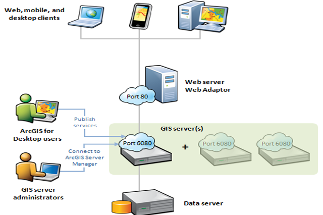
ArcGIS Server
ArcGIS is a complete integrated system of GIS software products. ArcGIS Server is the core server geographic information system software made by Esri. ArcGIS Server is used for creating and managing GIS Web services, applications, and data.
Explore
ArcGIS software For Desktop-Basic, Standard & Advance
ArcGIS desktop has a scalable set of products, in increasing order of namely, ArcGIS Server Basic, Standard and Advanced
Explore
ArcGIS Extensions
3D Analyst, Data Interoperability, Data Reviewer, Geostatistical Analyst, Network Analyst, Publisher, Schematics, Spatial Analyst, Tracking Analyst, Workflow Manager
Explore
EIGAP-Esri India GIS Academy Program
Esri India is conscious of GIS skills needed in the country and endeavours to make the current technology extensively accessible to the educational institutions. Esri India’s GIS Academy Program (EIGAP) therefore, is especially designed to provide qualified educational institutions with an economical way to acquire select Esri technology for teaching, learning and research.
View & Download PDF