
GeoStudio 2D
GeoStudio 2D offers a range of numerical analysis tools for simulating conditions above and below the ground surface. GeoStudio 2D can be used for a range of applications including natural soil and rock slopes, regional groundwater systems, excavations and open pit mines, dewatering systems, earthen dams and levees, reinforced earth structures, and tailings storage facilities. Three tiers are available to meet a variety of modelling requirements. The tiers and the corresponding functionality are summarized below or download detailed product comparison.
GeoStudio 3D
GeoStudio 3D offers a range of numerical analysis tools for simulating conditions above and below the ground surface. GeoStudio 3D can be used for a range of applications including natural soil and rock slopes, regional groundwater systems, excavations and open pit mines, dewatering systems, earthen dams and levees, reinforced earth structures, and tailings storage facilities. Two tiers are available to meet a variety of modelling requirements. The tiers and the corresponding functionality are summarized below or download detailed product comparison.
OpenFlows StormCAD
OpenFlows StormCAD provides roadway and site designers, stormwater master planners, and land developers like you with advanced tools to effectively deliver high quality design with minimized capital investments. It offers a complete approach to storm sewer design and analysis, from rainfall to outlet.

STAAD.Pro
STAAD.Pro is a comprehensive and integrated finite element analysis and design application that includes visualization capabilities, a simple user interface, and a wide range of design codes. You can analyze any structure exposed to static, dynamic, wind, earthquake, thermal, and moving loads. STAAD.Pro provides structural analysis and design for any type of project, including buildings, culverts, plants, bridges, stadiums, and marine structures.
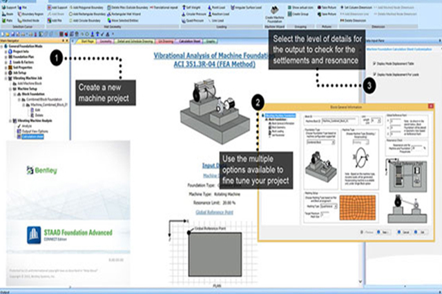
STAAD Foundation Advanced
STAAD Foundation Advanced is software for the analysis and design of foundations for buildings as well as plant structures, such as horizontal and vertical vessels. INTEGRATED ENVIRONMENT FOR FOUNDATION DESIGN The software provides three modes of operation – a general mode for superstructure data imported from STAAD.Pro® or Microsoft Excel or is user-specified; a plant mode for vertical and horizontal vessels, and self as well as mechanically anchored tanks; and a wizard-based mode for quick and easy data input for simple foundation types.
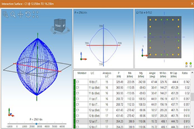
RCDC (STAAD Advanced Concrete Design)
STAAD Advanced Concrete Design takes the design of your concrete structures to the next level. Designed by practicing engineers for practicing engineers, STAAD Advanced Concrete Design adds onto the power of Bentley’s STAAD.Pro® analytical engine with robust concrete design
You can extend the reach of your business practice and take advantage of global design opportunities by using a wide range of international standards and specifications.
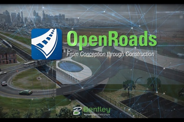
OpenRoads Designer
Extremely versatile, OpenRoads Designer is used for all types and phases of civil projects, large and small, by users at every level of expertise. It handles a wide variety of complex tasks with ease, including interchange design, roundabout design, site development, sanitary and stormwater network design, and the production of construction staking reports. Traditional 2D methods are manual and tedious, full of communication and data gaps, leaving you frustrated, exhausted, and with a project that costs you accuracy, time, and money. From survey through plan production and construction documentation, OpenRoads Designer is the one application you need to meet project
OpenFlows WaterGEMS
OpenFlows WaterGEMS is a hydraulic modeling application for water distribution systems with advanced interoperability, geospatial model building, optimization, and asset management capabilities. From fire flow and water quality analyses to energy consumption and capital cost management, OpenFlows WaterGEMS provides an easy-to-use environment for engineers to analyze, design, and optimize water distribution systems. WaterGEMS takes advantage of Bentley CONNECTservices by associating a hydraulic model with a CONNECT project.

OpenFlows SewerGEMS
OpenFlows SewerGEMS enables you to produce optimal urban sewer planning and overflow remediation analysis designs in an easy-to-use environment. You can design and operate sanitary or combined conveyance sewer systems by using built-in hydraulic and hydrology capabilities with a variety of wet-weather calibration methods. OpenFlows SewerGEMS takes advantage of Bentley CONNECTservices by associating a hydraulic model with a CONNECT project. CONNECTservices allows your team members to easily access the model.

PLAXIS 2D
PLAXIS 2D is a powerful and user-friendly finite-element (FE) package intended for 2D analysis of deformation and stability in geotechnical engineering and rock mechanics. PLAXIS is used worldwide by top engineering companies and institutions in the civil and geotechnical engineering industry. Applications range from excavations, embankments, and foundations to tunneling, mining, oil and gas, and reservoir geomechanics. PLAXIS is equipped with a broad range of advanced features to model a diverse range of geotechnical problems, all from within a single integrated software package.
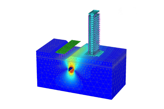
PLAXIS 3D
As infrastructure assets are crucially linked to subsurface environments, they are vulnerable to geotechnical risk. PLAXIS 3D allows you to make safe, cost-efficient decisions that offer fast, comprehensive analysis methods in a user-friendly platform. Perform 3D analysis of deformation and stability in geotechnical engineering and rock mechanics with PLAXIS 3D. The intuitive interface guides you across several modes to efficiently create models and is equipped with advanced features to conquer the most common or complex geotechnical projects.